

Cobalt:
The Town That Silver Built
This whimsical aerial view map of Cobalt comes to us courtesy of the artwork of Ruth Bernache, 1985. Many of the older landmarks still visible.
Brought to you by the Cobalt Historical Society.
Puzzles from the Cobalt Historical Society | ||
 |
 |
 |
Giachino's a Cobalt puzzle featuring the building we're in now as it was in 1945 as a grocery store |
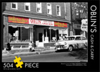
Oblin's Cash & Carry a Cobalt puzzle features this grocery as it was in 1945 on Lang Street. |
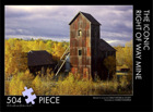
The Iconic Right of Way Mine Taken from a recent photo by Charles Dumaresq. |
 |
 |
 |
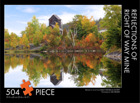
Right of Way Mine Reflections Taken from a recent photo by Sue Nielsen. |
Ontario Northland Railway Station Cobalt this Cobalt puzzle features the station as it was in 1945. |
Cobalt Public School from a photo circa 1955 |
 |
 |
 |
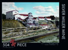
Silver Miller Mine as it was photographed circa 1950 |
Buffalo Mine & Water Tower -a George Cassidy print |
Nipissing 96 -a George Cassidy print |
 |
 |
 |
Townsite SentinelIn All Its Glory. Taken from a recent photo by Sue Nielsen. |
Cobalt: The Town That Silver Built whimsical map drawn by Ruth Bernache 1985 |
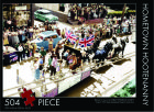
Hometown Hootenanny Cobalt's 1953 Silver Anniversary Parade photo by John Hunt |